Finding the law means finding the place
It’s been the standard mantra of The Legal Genealogist from the outset.
To understand the records, we have to understand the law.
And not just the law in some sort of generalized fashion, but the law at the exact time and in the exact place where the record was created.
 So, in anticipation of this weekend’s seminar of the Ventura County Genealogical Society, I set out to look at the law in Ventura County, California.
And ran right into the need to find out more about the history of Ventura County, California.
Because, until really quite late in California history, there wasn’t a Ventura County.
California was first settled by Anglo immigrants after Spanish missionaries arrived there in the late 1600s. So it has a long and rich history.
According to Wikipedia:
In 1697 the Jesuit missionary Juan María de Salvatierra established Misión de Nuestra Señora de Loreto Conchó, the first permanent mission on the Baja California Peninsula.[13] Spanish control over the peninsula, including missions, was gradually extended, first in the region around Loreto, then to the south in the Cape region, and finally to the north across the northern boundary of present-day Baja California Sur. A total of 30 Spanish missions in Baja California were established.
During the last quarter of the 18th century, the first Spanish settlements were established in what later became the Las Californias Province of the Viceroyalty of New Spain. Reacting to interest by the Russian Empire and, later, Great Britain in the fur-bearing animals of the Pacific north coast, Spain further extended the series of Catholic missions, accompanied by troops and establishing ranches, along the southern and central coast of California. These missions were intended to demonstrate the claim of the Spanish Empire to what is now California. By 1823, 21 Spanish missions had been established in Alta California. Operations were based out of the naval base at San Blas and included not only the establishment and supply of missions in California, but a series of exploration expeditions to the Pacific Northwest and Alaska.
The first quarter of the 19th century showed the continuation of the slow colonization of the southern and central California coast by Spanish missionaries, ranchers and troops. By 1820 Spanish influence was marked by the chain of missions reaching from Loreto, north to San Diego, to just north of today’s San Francisco Bay Area, and extended inland approximately 25 to 50 miles (40 to 80 km) from the missions. Outside of this zone, perhaps 200,000 to 250,000 Native Americans were continuing to lead traditional lives. The Adams–Onís Treaty, signed in 1819, set the northern boundary of the Spanish claims at the 42nd parallel, effectively creating today’s northern boundary between California and Oregon.1
California didn’t become a U.S. territory until 1847, as part of the treaty ending the Mexican-American War. Shortly thereafter, the discovery of gold at Sutter’s Mill in 1848 inspired a wave of settlers to head to the west coast in search of fortune, and led to a population explosion: from 14,000 in 1848 to 250,000 by 1852. In 1850 California became the 31st state.2
And throughout that entire history — from the first Spanish settlers through early statehood — there wasn’t a Ventura County.
As California counties go, Ventura is a bit of a Johnny-come-lately, created by the Legislature on 22 March 1872, to take effect 1 January 1873.3 Only eight of California’s 58 counties were created later than Ventura County was: Glenn in 1891; Imperial in 1907; Kings in 1893; Madera in 1893; Modoc in 1874; Orange in 1889; Riverside in 1893; and San Benito in 1874.4
So…
Where do we go when we need to know about this sort of thing? To determine what counties existed when, what the county lines were, how the boundaries changed?
There are some terrific resources out there, with one of the very best being the Atlas of Historical County Boundaries at The Newberry Library in Chicago. Despite the fact that its interactive map feature is still offline, having gone offline in the summer of 2015,5 the site is still one of the best research resources for county boundary information.
For every state, the Atlas offers an index of counties and equivalents, a consolidated chronology of state and county boundaries, individual county chronologies and bibliographic information for more research.
And we have hope that the interactive maps may come back…6 It hasn’t happened yet, but there are rumblings so… Fingers crossed there…
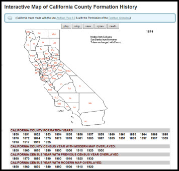
In the meantime, if you (like me) learn more effectively through a visual presentation, there are interactive maps online. Another source is MapofUS.org, a website where you can find county formation maps for every state, created with the software AniMap Plus 3.0 — and, of course, with the permission of the Goldbug Company, publisher of the software.
Be aware that you may need to use Internet Explorer rather than another browser, and need to tell the browser to show all content before the map feature will work properly, but there, you can see what California looked like in 1850, when it became a state — and what it looked like in 1874, after Ventura County was created.
And, of course, each state’s laws will tell the story of the counties as they are created and as their boundaries change. In Ventura County, for example, it lost territory to Kern County in 1919, confirmed in 1923, and again in 1991.7
Bottom line: finding the law at the time and the place always means starting with understanding the place.
SOURCES
Image: MapofUS.org.
- Wikipedia (http://www.wikipedia.com), “History of California before 1900,” rev. 21 Sep 2016. ↩
- “California”, History.com (http://www.history.com/ : accessed 13 Oct 2016). ↩
- “An Act to create the County of Ventura, to establish the boundaries thereof, and to provide for its organization,” Statutes of California Passed at the 19th Legislative Session, 1871-72 (Sacramento: T.A. Springer, state printer, 1872), 484; digital images, Google Books (http://books.google.com : accessed 13 Oct 2016). ↩
- John H. Long, et al., editors, “California: Individual County Chronologies,” Atlas of Historical County Boundaries, The Newberry Library (http://publications.newberry.org/ahcbp/ : accessed 13 Oct 2016). ↩
- See Judy G. Russell, “Dear Newberry…,” The Legal Genealogist, posted 21 July 2015 (https://www.legalgenealogist.com/blog : accessed 13 Oct 2016). ↩
- See ibid., “A gift from the Newberry,” The Legal Genealogist, posted 2 Dec 2015. ↩
- See Long, et al., editors, “California: Individual County Chronologies,” Atlas of Historical County Boundaries, citing Calif. Stats. 1919, 43d sess., ch. 470, secs. 3923, 3964, pp. 870, 908–909; Calif. Laws 1923, 45th sess., ch. 160, secs. 16, 57, pp. 336, 373; and Calif. Stats. 1991–1992, reg. sess., ch. 51, p. 150. ↩


Judy, another resource you may wish to consider is the interactive U.S. Historic Boundary Map tool at Randy Majors site here: http://www.randymajors.com/p/maps.html?m=1
I am not affiliated with with this site and receive no renumeration for recommending it.
Good suggestion, thanks!