Not as easy as it sounds
Reader Maureen was delighted with the Census Bureau publication that set out the directions to the census takers in each U.S. census from 1790 through 2000 that was featured in Monday’s blog post, Read the directions.1
 “I downloaded it immediately,” she said. “I love researching family in the censuses but am always aware that there is an enumerator who ‘translates’ and records the information the family provides.”
And then she asked the tough question: “do you know of any document that maps the census districts? Often they are District 12, xx County. But where is that? Knowing where your ancestors actually lived, the farm or house location, is part of the fun IMHO of doing genealogical research. But District 12, xx County is a lot of land. I could always go to land records of course…”
To which, of course, the only possible answer The Legal Genealogist can offer is…
It depends.
You see, the actual numbered enumeration districts that we often see in census records didn’t get those numbers until 1880.2 As explained by the National Archives:
An enumeration district, as used by the Bureau of the Census, was an area that could be covered by a single enumerator (census taker) in one census period. Enumeration districts varied in size from several city blocks in densely populated urban areas to an entire county in sparsely populated rural areas.
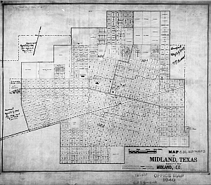
Enumeration district maps show the boundaries and the numbers of the census enumeration districts, which were established to help administer and control data collection. Wards, precincts, incorporated areas, urban unincorporated areas, townships, census supervisors` districts, and congressional districts may also appear on some maps. The content of enumeration district maps vary greatly. The base maps were obtained locally and include postal route maps, General Land Office maps, soil survey maps, and maps produced by city, county, and state government offices as well as commercial printers. Census officials then drew the enumeration district boundaries and numbers on these base maps.3
For the years when these numbered districts existed, if Maureen wants maps of those census districts, there are some pretty good options out there:
• Steve Morse’s Finding ED Definitions for (1880-1940) in One Step page is a terrific resources. Choose the year from the dropdown box at the top, then choose the state and the county and the district number, and you should get at least some descriptive information. For the 1930 district 16-1909 in the City of Chicago, for example, it tells us that it was in “Ward 50 (part), bounded by (N) Howard; (E) N. Western Ave.; (S) Touhy Ave.; (W) N. Kedzie Ave.”4
• FamilySearch’s collection, “United States Enumeration District Maps for the Twelfth through the Sixteenth US Censuses, 1900-1940”, offers more than 63,600 images of enumeration districts for all but the earliest census where enumeration districts were numbered. The images aren’t indexed, but the states are in alphabetical order, and the counties within each state are in alphabetical order.
• Search the National Archives Catalog for census maps as well. Many of the maps — particularly from 1940 and 1950 — have been digitized and are online.
But for earlier periods? Before 1880, what we really have are counties and then whatever subdivisions the person in charge of the census takers in that county — a census supervisor or the U.S. marshal or deputy marshal in the area — decided to use.5
And there isn’t any one place where you can go to get breakdowns on those areas. Even some libraries don’t get this right. The Cornell University Library page on U.S. Census Maps gleefully tells people looking for detailed information to go to the Historical Census Browser, a really neat online resource of the University of Virginia Library. Only one hitch. When you go there, it tells you in no uncertain terms that one of the things you can’t do there is “find information for areas below the county level (e.g. cities, census tracts).”6
The Census Bureau itself advises: “For locating pre-1880 maps, local city directories might be of help; the Library of Congress has a significant collection. Another collection that might be of help is the Sanborn Fire Insurance Maps, which began in 1867. Local street numbering systems probably had not changed all that much, though there would be new streets and changes to old ones. The maps also contain detailed descriptions of the buildings on the streets.”7
If the census itself references a township and range, you’re in luck, because that at least means you’re dealing with the federal land system and you can zoom in to the right area on a web map like the one from the U.S. Geological Survey. If it references a judicial district or magistrate’s district, state statutes may help with the definitions of the district lines.
And, as Maureen notes, if all else fails, … “always go to land records of course…”
SOURCES
- Judy G. Russell, “Read the directions,” The Legal Genealogist, posted 23 Nov 2015 (https://www.legalgenealogist.com/blog : accessed 24 Nov 2015). ↩
- FamilySearch Research Wiki (https://www.familysearch.org/learn/wiki/), “United States Federal Census,” rev. 30 Oct 2014. ↩
- “1940 Federal Population Census : Enumeration District Maps,” Resources for Genealogists, National Archives (http://www.archives.gov/research/ : accessed 24 Nov 2015). ↩
- Finding ED Definitions for (1880-1940) in One Step, One-Step Webpages by Stephen P. Morse (http://stevemorse.org/ : accessed 24 Nov 2015). ↩
- FamilySearch Research Wiki (https://www.familysearch.org/learn/wiki/), “United States Federal Census,” rev. 30 Oct 2014. ↩
- Historical Census Browser, University of Virginia Library (http://mapserver.lib.virginia.edu/ : accessed 24 Nov 2015). ↩
- “Where can I find enumeration district maps?,” Frequently Asked Questions, U.S. Census Bureau (https://ask.census.gov/faq : accessed 24 Nov 2015). ↩


Relatively off-topic for this post, but I thought I’d share:
I found it fascinating when I discovered an 1880 enumeration stamped “FIRST ENUMERATION REJECTED” and indeed, the family’s district was then re-enumerated. Lucky us as researchers that both copies were saved and subsequently filmed and then digitized. I researched it and found that there were a number of urban enumeration districts whose first enumeration was rejected in federal enumerations, and have since researched another family who was living in a different rejected enumeration district. I found this article a fascinating look at what was behind the bureaucracy and politics of census decisions.
What about the following microfilm collections at the National Archives:
M1931 Index to Selected City Streets and Enumeration Districts, 1930 Census
M1283 Cross Index to Selected City Street and Enumeration Districts, 1910 Census.
M1930 Enumeration District Maps for the Fifteenth Census of the United States, 1930
A3378 Enumeration District Maps for the Twelfth Through Sixteenth Censuses of the United States, 1900-1940.
T1224 Descriptions of Census Enumeration Districts, 1830-1890 and 1910-1950.
T1210 Descriptions of Census Enumeration Districts, 1900.
While I have only used the 1940 ED maps, it may bbe that these films offer a few clues depending on the area a person is researching. As you pointed out not every map still exists and the existing pieces of the puzzle can be found in many collections. It is certainly possible that this lack of clear boundaries may explain why a family is missing from the census.
Harold, those National Archives microfilms are what have been digitized and put online for the later years, and much of the info can be reviewed using Steve Morse’s site or FamilySearch. For the earlier years, T1224 is the best bet but it’s usually not much more than you can get looking at the census itself. The description of the info is:
In Spokane county Washington for 1900, 1910 and 1920 they used the voting precincts for enumeration districts and those voting precincts were listed in the city directories. Fun came in as the city decided to rename a bunch of streets in 1910, so you can have two houses next to each other listed on different streets in the 1910 census. I made my own map for the 1910 census enumeration districts years before it was indexed by the state genealogical society.
>>two houses next to each other listed on different streets in the 1910 census<< Oh my... what a pain!!