When county borders get fuzzy
As genealogists we all know how counties are created, right?
The legislature of the appropriate jurisdiction — colony, territory or state — passes a law creating the new county and setting out its borders.
Kind of like what happened in Texas in March of 1848 when Williamson County was created from land that had previously been part of Milam County.1 The new county was to include
… all that portion of Milam County… Beginning on the dividing waters of Colorado and Brazos rivers, at the South East corner of a survey of nineteen and three-fourths labors, known as the Post Oak Island survey; thence North 71 deg. East eight miles; thence North 19 deg. West, twenty miles; thence North 65 deg. West to the Salado; thence South 71 deg. West to the dividing ridge between the Brazos and Colorado waters; thence down said dividing ridge, with the meanders of the same to the beginning, … 2
That’s about as clear as it needs to be, right? And, according to the authoritative Texas Atlas of Historical County Boundaries, Williamson’s borders only changed three times: it lost some territory in 1852 when Burnet County was created; it gained some in 1853 from Bell County; and it swapped small areas with Bastrop County in 1856.3
Everything nice, neat and sealed, nearly 163 years before The Legal Genealogist heads off to speak to the Williamson County Genealogical Society at its 2019 seminar this coming weekend in Round Rock.
Except for one minor little problem.
Its border with Travis County.
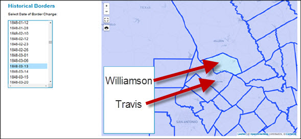
Now as you can see from this screen capture of what Williamson County looked like when it was formed in 1848, one of its longest borders was that wiggly border with Travis County on the south side. 4
And today, that’s the single longest border Williamson County has with any other county.
Yet as late as the 1920s, that border was in dispute.
So much so that the case had to go all the way to the Texas Court of Appeals to be resolved in 1928. Because Travis County was claiming and taxing lands north and east of where Williamson County said the border was, and Williamson County was claiming and taxing last south and west of where Travis County said the border was.5
Now the description of the reason for the case pretty much sums up why we’d care as genealogists, doesn’t it? With two counties duking it out over who gets to tax folks?
In other words, when county borders get fuzzy, where are the records going to be?
Sometimes they’re not going to be where we expect them to be.
And sometimes the law has to step in and settle that question for those poor border area taxpayers … and for us as genealogists.
Oh, and Travis County basically won. The Court set side a pair of surveys from 1859 and 1883 on the basis that Travis County had never legally accepted them as setting the border, and held that Travis County was entitled to a new survey for once and for all fixing the border between the two counties.6
Just in case you were heading out to look for tax records from the 1920s or so…
SOURCES
Cite/link to this post: Judy G. Russell, “Drawing the lines,” The Legal Genealogist (https://www.legalgenealogist.com/blog : posted 12 Mar 2019).
- See “An Act … to create the County of Williamson, …,” 13 March 1848, in H.P.N. Gammell, The Laws of Texas, 1822-1897, 10 vols. (Austin : Gammell Book Co., 1898), 3: 76-77; digital images, University of North Texas Libraries, The Portal to Texas History (https://texashistory.unt.edu : accessed 11 Mar 2019). ↩
- Ibid., §1, at 76. ↩
- John H. Long, ed., Texas Atlas of Historical County Boundaries: Individual County Chronologies, Atlas of Historical County Boundaries, The Newberry Library (https://www.newberry.org/ : accessed 11 Mar 2019). ↩
- Screen capture, Texas, 1848-03-13, Atlas of Historical County Boundaries, The Newberry Library (https://www.newberry.org/ : accessed 11 Mar 2019). ↩
- Travis County v. Williamson County, 4 S.W.2d 610 (Tex. App. 1928). ↩
- Ibid., at 611-613. ↩


Huh… my son lives in or near bastrop county
And then there are the “paper counties” that states or territories drew on maps but had other counties conduct most of the functions of government for them.
Yup. Wrote about that in Organizing the counties (2012) and Reprise: organizing the counties (2018).
…thank you again for your wonderful expertise Attorney Russell…. Tennessee and southern Indiana have counties that changed every year or two for generations…. gotta check um all…..!! Love your blog…
You’re welcome, but remember — I’m a genealogist with a law degree, not a lawyer who’s a genealogist (I don’t keep an active law license).
I kept running into three different counties on one set of ancestors even though they lived in the same place for generations. Then I visited! Noticed the one county line ran not along a street but in between two buildings. Suddenly I better understood why birth records were one spot, death records from the hospital a few blocks away were in another. Now I just simply look at all three counties when trying to find a record.
Yep, that sort of thing will surely wreak havoc on where the records will be!
Here is a genealogical chart for New York’s counties:
http://www.nysac.org/files/HistoryofCounties.pdf
I have a wonderful book, “Mississippi, Atlas of Historical County Boundaries”John H. Long, editor. This book was published in 1993. The smallest changes are shown and the references for the laws of the change are given as well. Since this book was published, much of the information of all the states can be found on line. https://publications.newberry.org/ahcbp/
However, the published book is much easier to use.
A similar thing happened in CA between Santa Cruz & Santa Clara counties in the mountain pass area formerly known as “Blood Alley”. The old Spanish land grants had run the border from one side of ghe peaks vs the other side. But until the advent of satellite mapping, no one realized there were small valleys hidden in the rough terrain ghat had never been discovered in foot surveys. DOT mandated a shuffle to get the proper county to pay for its share of improvements to the highway. So the land titles abruptly stop in one county & stsrt in the other. Later in the 1990s, I’m woerking as a temp for an Oregon branch bank taken over by a CA parent. A mortgage loan for the area was being held up because the title history didn cover the full history of the existing jouse…So I suggested tbat the title company officer look in tge adjacent county! The loan went through quickly after that. Why the counties had not been required to exchange or make reference to prior totke histories in the affected properties, I’ll never know. But my temp time with the mortgage dept was extended for the project several times!!