Iowa in Nebraska
There is something distinctly disconcerting about driving down a perfectly straight road between Eppley Airfield — the Omaha, Nebraska, airport — and the City of Omaha.
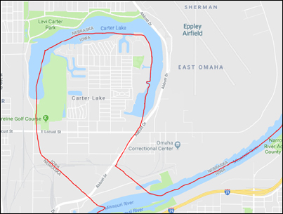 As The Legal Genealogist discovered this past weekend, while going to and from the Nebraska State Genealogical Society conference in Columbus, if you have your GPS on for that part of the ride, when you’re just a short distance from the airport, a disembodied voice will announce: “Welcome to Iowa!”
And your brain will respond: “Say what?”
Yep. Despite the fact that the Missouri River is actually over there, and you’re over here, and despite the fact that the Missouri River is the boundary between Iowa and Nebraska, you have indeed entered Iowa. Briefly.
And here’s why, as I explained for the first time some years ago, before I’d ever experienced this for myself.1
It’s accretion when the ordinary routine flow of water ends up taking dribs and drabs of soil, sand and rocks from one side of the river and depositing them on the other side of the river so slowly you don’t notice that the east bank is retreating and the west bank is advancing.2 It’s avulsion when some sudden change in the water’s flow — usually caused by something dramatic like a flood or an earthquake — changes the course of the river essentially overnight.3
Wonderful. So what?
I’m wounded — wounded, I say — that you might even think to ask.
Take out that deed again. Read its terms carefully. Doesn’t it say that the boundary between John’s land and Robert’s land is the river or the creek or the stream?
And reread the statute establishing the boundary between Iowa and Nebraska one more time. Doesn’t it say the boundary is “the middle of the main channel of the said Missouri River”?4
So what happens to the boundary if there’s accretion? How ’bout if there’s avulsion? That’s “so what”!
Ah… therein lies the tale. And it leads — no surprise, here — right into the courts and, in the case of Iowa and Nebraska, right into the United States Supreme Court.
Let’s get one thing straight about the Missouri River. It floods. Regularly. Routinely. Despite the best efforts of the Army Corps of Engineers. And that’s nothing new. It did the same thing back when the boundary was formed. And it kept doing it. Major floods occurred in 1881, 1943, 1952, 1967, 1978, 19935 and, of course, in 2011.6
And at least in the 19th century, the river current was “rapid, far above the average of ordinary rivers; and by reason of the snows in the mountains there are two well known rises in the volume of its waters, known as the April and June rises. The large volume of water pouring down at the time of these rises, with the rapidity of its current, has great and rapid action upon the loose soil of its banks.”7 All that loose silt, of course, gave the river its nickname, the Big Muddy.
Now imagine what the combination of floods and erosion did to the course of the river. Yep. It moved it. Enough so between 1851 and 1877 that “there were marked changes in the course of this channel, so that in the latter year it occupied a very different bed from that through which it (formerly) flowed,” and Nebraska sued Iowa to settle disputes over just where the boundary was between the two states.8
Under the Constitution of the United States, suits between states are heard directly in the United States Supreme Court.9 So the dispute landed squarely in the High Court’s lap.
First, the Court reviewed the basic law:
It is settled law, that when grants of land border on running water, and the banks are changed by that gradual process known as accretion, the riparian owner’s boundary line still remains the stream, although, during the years, by this accretion, the actual area of his possessions may vary. … “The question is well settled at common law, that the person whose land is bounded by a stream of water which changes its course gradually by alluvial formations, shall still hold by the same boundary, including the accumulated soil. … Every proprietor whose land is thus bounded is subject to loss by the same means which may add to his territory; and, as he is without remedy for his loss in this way, he cannot be held accountable for his gain.”…
It is equally well settled, that where a stream, which is a boundary, from any cause suddenly abandons its old and seeks a new bed, such change of channel works no change of boundary; and that the boundary remains as it was, in the center of the old channel, although no water may be flowing therein. This sudden and rapid change of channel is termed, in the law, avulsion. … “(I)f the change is violent and visible, and arises from a known cause, such as a freshet, or a cut through which a new channel is formed, the original thread of the stream continues to mark the limits of the two estates.” …
These propositions, which are universally recognized as correct where the boundaries of private property touch on streams, are in like manner recognized where the boundaries between States or nations are, by prescription or treaty, found in running water. Accretion, no matter to which side it adds ground, leaves the boundary still the center of the channel. Avulsion has no effect on boundary, but leaves it in the center of the old channel.10
Applying those rules, the Court then held that “the law of accretion controls on the Missouri River, as elsewhere; and that not only in respect to the rights of individual land owners, but also in respect to the boundary lines between States. The boundary, therefore, between Iowa and Nebraska is a varying line, so far as affected by these changes of diminution and accretion in the mere washing of the waters of the stream.”11
But because the evidence showed that “in 1877 the river above Omaha, which had pursued a course in the nature of an ox-bow, suddenly cut through the neck of the bow and made for itself a new channel,” the Court held that that change did “not come within the law of accretion, but of that of avulsion. By this selection of a new channel the boundary was not changed, and it remained as it was prior to the avulsion, the center line of the old channel.”12
So that settled things, right? Sure, it did. For a couple of weeks or months or years, until the next change occurred, and somebody in one state argued a piece of the other state was now theirs. By 1943, not even the two states could say where the original border was any more.
The problem was that “the fickle Missouri River . . . refused to be bound by the Supreme Court decree (of 1892). In the past thirty-five years the river has changed its course so often that it has proved impossible to apply the court decision in all cases, since it is difficult to determine whether the channel of the river has changed by ‘the law of accretion’ or ‘that of avulsion.’”13
So they entered into a compact — an agreement — to fix the border for once and for all.14 And that settled things, right? Well… um… er… no. The states ended up back in front of the Supreme Court in 1972 in yet another border dispute, with Nebraska asking the Court to reject Iowa’s claim to 30 separate land areas formed by changes in the river before and after 1943.15
The Court agreed with Iowa on some of the claims and Nebraska on some of the claims and the two states haven’t been back in court over the borders since then.
At least not yet.
Which leaves that ox-bow section of Iowa on the Nebraska side of today’s Missouri River, and making your GPS wake up and welcome you to Iowa — which you might think should be on that side of the river — as you drive between Omaha and its airport on what surely seems like a perfectly straight road on this side of the river.
And, oh, by the way, leaving our ancestors in court for exactly the same reasons as Iowa and Nebraska fought it out: complaining of or defending against claims that a creek or river or stream bed had changed too suddenly for the boundary line between properties to have gone with it.
So if you come across a case like that, remember: if it happened so slowly you couldn’t watch it happen, it’s accretion and the boundaries move with the waterway, but if it happened essentially overnight, it’s avulsion and the boundaries stay the same.
At least if you, unlike Iowa and Nebraska, can figure out where the boundaries were in the first place…
SOURCES
Image: Google Maps, Eppley Airfield, captured 30 April 2018, with the border of Iowa and Nebraska highlighted in red.
- See Judy G. Russell, “As the river flows,” The Legal Genealogist, posted 23 July 2012 (https://www.legalgenealogist.com/blog : accessed 30 Apr 2018). ↩
- Henry Campbell Black, A Dictionary of Law (St. Paul, Minn. : West, 1891), 18, “accretion.” ↩
- Ibid., 110, “avulsion.” ↩
- “An Act to define the Boundaries of the State of Iowa, and to repeal so much of the Act of the third of March, one thousands eight hundred and forty-five as relates to the Boundaries of Iowa,” 9 Stat. 52 (4 Aug. 1846). ↩
- Nebraska Department of Natural Resources, “Historic Floods on the Missouri River: Fighting the Big Muddy in Nebraska,” PDF, U.S. Environmental Protection Agency (https://semspub.epa.gov/ : accessed 30 Apr 2018). ↩
- Wikipedia (http://www.wikipedia.com), “2011 Missouri River floods,” rev. 14 Apr 2018. ↩
- Nebraska v. Iowa, 143 U.S. 359, 368 (1892). ↩
- Nebraska v. Iowa, 143 U.S. at 359. ↩
- United States Constitution, Article III, § 2. ↩
- Nebraska v. Iowa, 143 U.S. at 360-361. ↩
- Ibid. at 370. ↩
- Ibid. ↩
- Erik M. Eriksson, “The Boundaries of Iowa,” 25 Iowa Journal of History and Politics 163, 234 (1927). ↩
- Iowa-Nebraska Boundary Compact of 1943, Iowa Acts of 1943, c. 306, Nebraska Laws of 1943, c. 130, P.L. 78-134, 57 Stat. 494 (1943). ↩
- Nebraska v. Iowa, 406 U.S. 117, 120-121 (1972). ↩


One more link: https://www.xkcd.com/1986/
I love it!!!!
Kaskaskia, IL is another example: it’s been on the “wrong” side of the Mississippi River since 1881. Has an IL area code and a MO zip code. Though since the mid-1990s the land on the “wrong” side of the river hasn’t had any year-round residents.
By golly cousin, you had my ol head spinning with those two new words.
Someone said the sidewheeler steamboats gave the Missouri the name of “The Big Muddy”. Here is a list of sidewheelers sunk by the mighty Missouri. http://www.kchsoc.org/cultural/boatinfo/steamboating_onmissouririver_encrypted.pdf
Cool stuff! Thanks!