We’re getting the interactive maps back!
It was back in July when The Legal Genealogist made what was then a common trek out onto the ethernet to one of the sites that, to a genealogist, is simply indispensable.
Now, I’m not going to sit here and say I don’t have a ton of sites in my bookmarks that I could live without if I had to.
But very high on the list of sites I can not do without is the interactive Atlas of Historical County Boundaries at Chicago’s Newberry Library.
When you have families, like mine, that migrated during the early days of the Revolutionary War to Rowan County, North Carolina, and then lived in Burke County, Yancey County and Mitchell County — but never moved after arriving in North Carolina — you really need the interactive map database at the Newberry Library.
It’s the easiest, most complete site to track county boundaries, with “(m)aps and text covering the historical boundaries, names, organization, and attachments of every county, extinct county, and unsuccessful county proposal from the creation of the first county through 31 December 2000.”1
And the very best part, until that day back in July, was that I could “(c)hoose a date (day, month, and year) to view historical county configurations against the modern county network (and use) the toolbar to zoom, pan, measure, view descriptions and citations, or print a desired map.”2
So my heart sank — absolutely sank to my toenails — when I surfed over to the Newberry Library website and saw what it was showing.
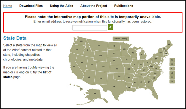
Oh, no. No no no. I did not want to see those words:
Please note: the interactive map portion of this site is temporarily unavailable.
Now any time you see a message like this, you know that the most likely situation is that there’s some sort of technical glitch that will take some serious resources to fix… and that those serious resources wouldn’t be committed unless and until the site got rock solid evidence that the missing functionality was important to the site’s users.
So the word went out to the genealogical community: if this is as important to you as it is to me, we need to make sure the Newberry knows that.3
And guess what?
The Newberry listened.
The maps are coming back!
From Jennifer Thom, Director of Digital Initiatives and Services, and Matt Rutherford, Curator of Genealogy and Local History, comes the word that:
In the years since the Atlas site launched, there has been an explosion of geospatial software, tools, and services. We’ve had many options to review and consider the past few months. We’re pleased to say that we’ve signed an agreement with Galecia Group, the developers who are also working on an upgrade of our Chicago Ancestors site. We anticipate a prototype of the new Atlas in early 2016 and hope to launch the site for researchers in Spring 2016.
The Atlas is an important tool for many researchers and we appreciate the response we’ve had from you in recent months. We’re excited to bring these important maps back for you, with a fresh new interface. In the meantime, other important Atlas of Historical County Boundaries features (such as downloadable shape files, chronologies, bibliographies, metadata, and commentaries) are still accessible.4
The genealogical community could not have gotten a better holiday gift.
To the Newberry, our most sincere thanks. We are so very grateful!
We can’t wait to see the new Atlas of Historical County Boundaries.
Is it spring yet?
SOURCES
- “Atlas of Historical County Boundaries,” entry for New Jersey, Newberry Library (http://publications.newberry.org/ahcbp/ : accessed 20 July 2015). ↩
- Ibid. ↩
- See e.g. Judy G. Russell, “Dear Newberry…,” The Legal Genealogist, posted 21 July 2015 (https://www.legalgenealogist.com/blog : accessed 30 Nov 2015). ↩
- Thom and Rutherford to Russell et al., “Newberry update: Atlas of Historical County Boundaries,” email, 23 Nov 2015. ↩


Snoopy won’t be the only one doing a Happy Dance!!! YAY!
Our whole community is SO GRATEFUL for what The Newberry is doing to bring this back!!
An indispensable resource, so glad it’s coming back soon.
You and me both (and the whole community to boot!) !
When you suggested we email the Newberry to ask them to return these maps, I did. I doubt mine turned the tide, but all of ours together must have helped! I have pre-Revolutionary War ancestors who moved all over South Carolina, then to North Carolina after the War. Things got confusing when they didn’t move, but their counties did. Then the family moved to central Illinois, and many of them stayed there for generations. It took me a long time to discover that, again, some of them stayed put but the county lines moved. So these maps are important to me too. Likewise, when my branch of the family moved to eastern Washington State around 1900, the counties were huge and sparsely settled. As they got filled in, some of the counties got divied up. So maps like the Newberry used to have, and will again, are invaluable. Can’t wait!
Thanks for your help in letting the Newberry know how important these maps are!!
We need all the help we can get, especially beginners in family history. My sir name is Irish, so finding information on that side of the family is so hard to find.
This is early Spring. I searched around a bit for the Atlas of historical County Boundaries and couldn’t find an active link. Not accessible yet or did I miss it…?
Thanks…Nancy
Not yet, darn it…